There has been a ton of speculation about the Apple Maps announcement this week. The announcement was perhaps the worst kept secret of the event. Everyone knew it was coming. Google and Apple have a huge need for you to use their phones for your location based activities so that eventually when the mobile advertising market grows up, they can capitalize. What better way to capture your location based activities than to create a robust app that navigates you whether driving, walking, biking, or using public transportation. Neither Google or Apple could care less about the navigation itself. They care about knowing about your navigation. And therefore, both have now planted both of their feet firmly in the navigation app space. The only way to do it, they believe and I agree, is to provide a robust navigation app that will be your go-to solution for all forms of personal navigation so they have a constant opportunity to serve you mobile ads.
What does this Apple announcement mean? No one knows for sure but here are my thoughts.
TomTom
No one knows the details of the relationship between Apple and TomTom for sure, other than the very short press release that TomTom released. The only fact that we know is that Apple is using TomTom's maps (TeleAtlas actually - owned by TomTom). What we do not know is:
1) Did Apple only buy the underlying mapping data from TomTom (TeleAtlas) and Apple built their own UI on top of that underlying mapping data?
2) Is the routing algorithm TomTom's or Apple's? If TomTom's, does it use IQRoutes data?
3) Will Apple's crowd sourcing feed back into TomTom to support TomTom's IQRoutes feature?
4) Will Apple's crowd sourcing traffic feature feed back into TomTom's traffic service?
If Apple only bought "dummy" map data from TomTom then in my opinion TomTom sold it's soul to the devil because of it's reportedly precarious financial position. Apple has a lot to prove in terms of their ability to develop their own routing algorithm and ETA calculations if they are not using TomTom's. Only after consumer use of the new app will we know for sure how good they are at this new game.
I've said many times that TomTom's main remaining value in the US is it's intellectual property: IQRoutes and HD Traffic. Those two services need users, and lots of them, or these features wither and die. Without users, TomTom cannot sustain the accuracy and timeliness of these features. And without those features, TomTom has little to offer the US consumer that is unique. TomTom already missed the boat badly in the US by not expanding their user base by adding Android users.
We know that Apple has announced that the Apple Maps app will feature crowdsourced traffic. What we do not know if is if it will also contain historical traffic. If it does, this would presumably have to be TomTom IQRoutes because Apple has no history in this space by which to have any historical traffic data. If it does not use historical data at product launch, then Apple has a long way to go to catch up to their competitors. Not having historical traffic data would be a bad sign for those hoping that the Apple Maps app will be back feeding TomTom's IQRoutes and HD Traffic.
If Apple's app is not back feeding TomTom's IQRoutes and HD Traffic then that is a clear sign of the trouble that TomTom is in in my opinion. Apple clearly has the user base to build up their own data that would resemble IQRoutes and HD Traffic. It would take them several years, less in larger cities, but they clearly have the user base to build it like no one other than Google can. It would appear that Apple does not necessarily need TomTom, except for a short term jump start. Clearly the release of Apple Maps will cause a significant reduction in sales of TomTom's own iPhone app. There would be little to justify the expense. If Apple is not using IQRoutes or HD Traffic, then those features would remain as selling points for TomTom's own app, but that advantage will be short lived as Apple builds up their own data. And Apple's own app will likely simply be more fun to use anyway, further drawing users away from TomTom's own paid app. The Apple app will be integrated with Siri and you can bet that Apple will nail the UI.
If Apple Maps is not feeding back into TomTom IQRoutes and HD Traffic then those features, in my view, are dead in the US. Apple Maps will drastically draw users away from TomTom's own apps, their PND's are already in deep decline. There simply do not appear to be enough users out there using IQRoutes and HD Traffic "feeder devices" to make those features viable.
After all of that explanation and speculation my prediction is that Apple buys TomTom.
Garmin
Garmin's public comment downplaying the impact of Google Maps screams of a historical 800 pound gorilla still trying hard to be seen as the major player it once was in the industry. Garmin is positioning itself as the "premium" player in a market of less-featured free or freemium solutions. The problem with that strategy, as I pointed out in previous blog posts, is that their so called premium devices are typically full of "half baked" features that never seal the deal. They get their devices 85% right in my view, but never finish the 15% of the features that would truly put it over the top, justify its high cost, and make it too good to pass up. Instead, they are onto developing another 10 skus of product, end-of-life'ing devices after 12 -16 months and trying to convince me to pay another several hundred dollars for the next "latest and greatest" device. Fool me once Garmin....Actually you fooled me twice, I just bought a 3590 after owning nothing since the 885. Not sure there is another Garmin device in my future that I can see.
Garmin is the only major player left that is at the mercy of a twice removed company for its core foundation - the maps. Garmin is at the mercy of Navteq, who is in the hands of Nokia, for its maps, a problem that no other player has. Part of Garmin's premium justification is Navteq maps - once the clear premier mapping provider. In the hands of Nokia, I am not sure Navteq remains in that position long term.
The future of Garmin's app on the iPhone seems destined to niche status, perhaps only for those customers sophisticated enough to know that they want Navteq maps and are willing to pay the fee, or for customers that still are blindly brand loyal to Garmin.
Garmin has no play in the Android space. Google will continue to exert pressure on Garmin and Garmin simply has no answer. Smartphone Link (Garmin's Android app that mates to a Nuvi via bluetooth) appears to be a lightly used niche app as evidence by the download numbers. For the record, I use the app and love it.
Garmin's problem with Smartphone Link however is that it holds my phone hostage because of its use of my bluetooth connection. That means I can't use a bluetooth headset, I can't use the bluetooth phone feature of my car and I can't use the bluetooth telematics feature in my car with its in-dash apps. Am I willing to give that up long term just to maintain my Garmin Nuvi? No. Smartphone Link is Garmin's Android v2.0 strategy and I think this will also be short lived, like the phones they tried a couple years ago.
Garmin seems only to be able to compete by convincing customers that premium PND's are the way to go. I don't see a competent and sustainable go-forward strategy yet from them to compete in a smartphone dominated world.
My prediction: Garmin buys Navteq from Nokia and tries to position themselves as the premium map set and the premium navigation solution. They may get smart about developing an Android app and continue their iPhone app development and also position their apps as the premium answer to the free alternatives. Whether they have enough features to truly differentiate and justify their premium cost remains to be seen.
Google
Frankly, I don't see Google impacted much by Apple Maps. I don't see that iPhone users make up a significant portion of Google's crowdsourcing user base. I don't see that Google's data will miss these users much. I also don't think Apple Maps will convert any significant quantity of Android customers. I just don't see that Apple Maps provides any advantage over Google Maps. I think that iPhone customers will remain iPhone customers and Android customers will remain Android customers. There is no doubt though that there will be a huge competition between Google and Apple to see who has the best navigation app to attact new users. This is a win-win for consumers. We can expect great strides from both players as they try to one-up each other.
Inrix
I don't know what to think about Inrix. I like their app and I like their traffic content, but I never use their app. Why? Because knowing the existence of traffic is only part of the equation. I want to know what to do about it and their app (at least for Android) doesn't tell me that. Frankly, the Inrix app is just not an app that will get my attention on my phone right now. From what I know, I don't see that Inrix has any role in either Google or Apple in this new smartphone navigation app battle. I am not knowledgeable enough about their business relationships to comment on what role Inrix has going forward that would have a direct consumer impact.
Others
I don't consider the other players worth spending much time on at this point. This is clearly a Google versus Apple battle. Players like Waze offer a unique solution. But I can't see them offering a compelling enough case to draw customers away from Google or Apple in enough quantity to create critical mass for their own crowdsourced apps. I see Waze as a small niche player that will drawn numbers similar to Open Street Map or Mapquest. Actually, I would bet good money that Waze will be acquired at some point.
ALK, TeleNav, Sygic, NDrive and the others have no upside in my view. There is just no compelling story here for any of them to justify not using Google or Apple. Once the general public gets a taste of the power of crowdsourced historical and real time traffic, these small niche players that don't have that data will have a hard time making a case for their app. Perhaps the inclusion of Inrix data in some of these apps will continue to be a compelling enough drawn for some people that are smart enough in this industry to know the difference and care but I have a hard time seeing a long term business case for these other players.
The same goes for the small PND players like Magellan, Rand McNally, etc. These players will turn into niche suppliers for specific industries like trucking, RV/Motorhomes, etc.
Conclusion
Who knows? How is that for a conclusion? We all talk smart about what will happen but the truth is that none of us know. I see:
1) Google continuing down their current path, crowdsourcing map data, using their users as probes for their historic and real time data, and using field vehicles primarily for streetview.
2) Apple will get a few months into their Apple Maps app and determine their confidence in building their own map data (ala Google) including using their users as probes to build their own historic and real time data. If they see roadblocks or think the data is building too slowly, I can see Apple making a play for TomTom to get TeleAtlas. I could also see Apple buying Waze instead to get the technology that Waze has and apply it to the user base that Waze doesn't have.
3) Garmin will remain as the viable premium old-school player in the market, still trying to convince the user base to buy dedicated devices. I can see Garmin making a play for Navteq as a fire sale from Nokia and trying to mold themselves into a services and software company. Their play could be premium map data, not relying much on crowdsourcing, built into premium apps and dedicated premium PND's.
That is my two cents on recent events.
Thursday, June 14, 2012
Friday, June 8, 2012
The Case for Incremental Map Updates or "Why Google and Waze might be eating Garmin & TomTom's lunch!"
Nothing
frustrates a GPS user more than map mistakes. After all, that is what a GPS is supposed to
do – efficiently route you to your destination on a map. Every user has an expectation, as unrealistic
as it is that the maps will always be timely and accurate.
Rational
users know that maps in your GPS will always and forever be a lagging
technology. The maps will ALWAYS be out
of date. The digital roads will always be
“built” after the physical roads are. Even
though we understand that, it doesn’t make it any less frustrating when we
experience a GPS map error.
However,
that doesn’t mean that we shouldn’t expect the GPS industry to innovate and
compress the time between the physical road and the digital road. Has the legacy GPS industry done that? Are they resting or are they innovating?
Let’s
take a look at the legacy GPS industry – those manufacturers primarily deriving
their consumer revenue by selling hardware.
We know these brands well – Garmin, TomTom, Magellan, etc. These legacy manufacturers sell hardware that
contains digital maps on the device. Contrast that to a company like Google, Waze
or Mapquest that is primarily a software company that serves you the maps
online without dedicated GPS hardware.
(However, with Google’s announcement this week that offline maps are
coming to Google Maps for Mobile, the line will further blur – not good for the
legacy companies.)
Let’s
start with a basic undeniable truth. The legacy GPS industry as we know it is
threatened by the smartphone. That pressure is only going to increase not
decrease. Garmin tried to play in the
smartphone market but couldn’t shake the obsession to make hardware. The idea crashed and burned. Now they are trying smartphone idea 2.0 which
is the Garmin Smartphone Link app, which bridges the smartphone to the traditional
PND through a Bluetooth data connection.
The Android Market shows the app has been downloaded between 10,000 and
50,000 times. That is a paltry fraction
of the GPS market (Google Navigation has been downloaded between 100 and 500
MILLION times) so it remains to be seen how long Garmin’s approach will
continue to be supported by development resources. Coincidentally, a smartphone “link” to a PND
was something that TomTom did years ago, but for all practical purposes has
abandoned. In the smartphone space, TomTom
has been available for the iPhone for a while.
But as you know, they have been AWOL on Android despite talking about it
publicly for nearly 3 years now. Time will tell if it is too little, too late
should it ever become available. Garmin
too, has an iPhone app but has shown no signs of making a US app available for
Android.
This
is not a blog post to discuss the merits of a dedicated GPS versus a
smartphone. There are many things that a
legacy GPS does better than a smartphone.
But there is no question that the legacy GPS is finding itself in a
position of having to justify itself and its cost more and more every day. Why spend $399, $299, $199 or even $99 when a
smartphone solution is “good enough.” The
phrase “good enough” should make Garmin, TomTom and the others cringe! The only thing that the likes of Garmin and
TomTom should be focused on is to make their products so good that the
smartphone solutions aren’t “good
enough.” Alternatively, they could just
become really great software developers and get firmly in the smartphone app
game.
I come back to my opening paragraph and say that one of the things most important to GPS users is the maps. Customers want accurate and timely maps. Garmin could be leveraging their dominance in the industry by providing an innovative delivery mechanism for their maps. But to date, there is no public evidence that Garmin is or will do so. And finally, after a long introduction, that is the subject of my blog post today: the lack of innovation in the delivery of map updates.
Take
a look at some advertisements that you see from Garmin or TomTom. You'll see
that they are probably promoting the fact that their products have quarterly
map updates. But, let’s step back. Is
that supposed to be something consumers should be excited about? In 2012? I am not so sure about that. The fact that they still are advertising that
as a feature today, I would argue, points to a lack of innovation in their
industry. They should be embarrassed by that, not proud. I am not sure that they see it that way
though.
The maps that Garmin uses in their GPS devices actually come from a vendor, Navteq (owned by Nokia). TomTom’s maps come from TeleAtlas, which TomTom owns. I have absolutely no inside knowledge of how this works. The following is complete speculation on my part. I could be completely wrong on this, but I’ve observed the industry for long enough that I think I know some of the details of how it works.
The
quarterly update that you're spending hours downloading and installing tonight isn’t
accurate up to the time the map is released.
There is a lag between the data that Navteq provides to Garmin and the
data that Garmin actually sends out to customers. That seems obvious, but you still see posts
on the Internet from customers complaining that their street was added 6 months
ago – why isn’t it in the map update I just got?
There
is an additional lag inside Navteq.
Certainly Navteq faces a “cut off” point in order to prep their data for
delivery to Garmin. And thus the data
that Garmin gets from Navteq is also not the most current data available. It is only the most current data that Navteq
has in deliverable form. The actual data could be several quarters, to
a year old or more.
The other day, I discovered a simple map error. Within a large intersection, an errant one-way segment was defined. It prevented a simple left turn from one major road to a US highway. It is the kind of thing that makes you wonder how the error gets there in the first place, that intersection hasn’t changed in 10 years, but nonetheless, it is there. It took me less than 5 min. to correct this error on Navteq’s website.
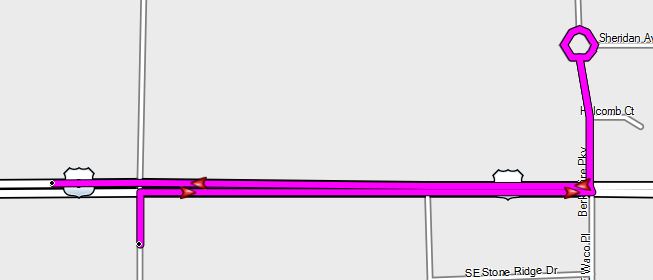
Five
minutes. The error was fixed, by me, in
five minutes. That, however, is not the
important timeframe to care about. The
question is, how long will I have to wait until that simple 5 minute fix ends
up in my GPS so the maps quit generating a ridiculous work-around at that
intersection? I will bet that I will
wait a year or more before I will see that error actually corrected in my
GPS.
Waiting
a year for a map error fix that took me 5 minutes to correct online will
ultimately try the patience of the legacy GPS consumer in a smartphone age to
the point that customers, at some point, will simply not put up with it any
more. Again, to sell a $299 PND in a smartphone
age Garmin has to justify that cost, every day.
Waiting over a year for a simple map correction is not a great way to
justify a $299 product cost to your customer.
If
the legacy GPS companies don’t start thinking and start innovating the delivery
of their maps quicker than they are, I believe that they will continue to lose
ground.
The
legacy GPS companies might argue that waiting one quarter for map updates is a
great thing, right? After all, it was only two years ago that we were receiving
map updates once per year. And, after
all, if you buy a car with a built in GPS, those updates are still only once a
year. See! The legacy GPS companies ARE being
innovative!
How
legacy companies do compared to built-in GPS companies isn’t the relevant
question. The relevant question is how the
legacy GPS companies do in comparison to their REAL competitors – nimble
software-thinking IT-centric companies that would laugh at thinking about the
prospect of only updating their product once a quarter. These competitors are going to eat their
lunch someday if they don’t change their approach.
In
the time Garmin has continued to offer only quarterly updates, other companies have
been thinking strategically and blowing the quarterly map delivery model out of
the water.
Of course I'm speaking about alternative map delivery approaches from the likes of Google Navigation and Waze. Now, let me make something perfectly clear before I go on. I am in no way suggesting that the current iteration of these competing products are best in class or that they are better products than my current legacy GPS. I do not believe that they are. But again, that isn’t the question. The appropriate question is are they “good enough” to not spend another $299 on a PND and rather, to “settle” for the free alternative. Garmin’s job is to widen the gap to the point that the answer is no. In my opinion, Garmin is doing nothing to widen the gap.
Whether
customers are familiar with Google’s MapMaker map editor or Waze’s editor is
not really the point. I would argue that
most customers also don’t contribute to Navteq’s Map Reporter or TeleAtlas’s
Map Insight editor either. The relevant
point is what happens downstream of those editors and what that means to the consumer.
Google
and Waze have revolutionized the mapping world by developing a solution that
pushes edited and moderated map changes to the customer quicker than the industry
has ever seen before. As a Google Trusted
Editor for my area, most edits that I map in Google MapMaker are updated instantaneously in the web version of
Google Maps. THAT is innovation. Those edits find themselves pushed to the
Google Maps for Mobile platform in a couple of weeks. Waze has a similar track record of updates,
making changes available to customers within weeks of the initial edit.
The
Google and Waze approach sets the bar going forward. It moves the “is it good enough” bar closer
to the free smartphone solutions and away from the dedicated PND. Garmin just sits and lets it happen. In my opinion Garmin is in a bit of a bind. After all, they are using Navteq maps, which
are owned by Nokia. Garmin gets to deal
with the corporate bureaucracy of Navteq and
Nokia, not to mention the bureaucracy within Garmin itself. The chance of nimble innovation with these
three goliaths is likely too much to ask for frankly.
TomTom was on the right track, purchasing TeleAtlas so they own both the map and the delivery mechanism for the maps (the PND and the software). However, looking at the example of TomTom for Android, TomTom has proven to be no more nimble now than they were when TeleAtlas was a separate company.
What
should Garmin do? Here is my
premise: It is INSANE that in 2012, we
are still downloading 2 GB map updates once per quarter. No, I not suggesting that we should be
downloading 2 GB map updates once per month or once per week. I am suggesting that we should be downloading
10 KB or 100 KB or 2 MB map updates once per day, once per week or on whatever
schedule we wish. TomTom is well known
for stating that 18% of the road network changes each year. If that is true, why are we downloading 100%
of the road network every single quarter?
If a single map update is 2 GB that means that only 360 MB of that map
actually changes in a year. Yet, in a
year, if we perform all 4 quarterly updates, we are downloading 8 GB of data to
obtain 360 MB of updates.
I
have to wait over a year for a small (but important to me) map update to get
incorporated into a massive 2 GB quarterly map update when it could have easily
been pushed to me as a 10 KB map update a couple weeks after I fixed the error
online.
Garmin
should be innovating and pushing incremental map updates to customers. Full 2 GB map updates should be history. Incremental map updates would move the bar
further away from the Google Navigation and Waze approaches and breathe life
towards Garmin’s corner in the battle of “is it good enough?” In fairness, TomTom does have their MapShare
program which pushes some incremental map changes to customers. However, we still face a large quarterly full
download every quarter regardless of whether we use MapShare.
Critics will say “you don’t get it.” And you are right, I probably don’t. But I shouldn’t have to either. I am the consumer and it is my $399 that
Garmin is trying to get. Clearly as the
industry leader, Garmin should have the intellectual talent to innovate in
these kinds of ways. What I believe they
lack is the will. The more product
generations that I wait over a year for a small map fix, the less likely it is
that I will spend that $399 again with Garmin.
THAT, I do get. The solutions
from Google Navigation and Waze are very close to “good enough” today and that
gap appears to be doing nothing but closing.
Garmin should be very concerned with that.


Saturday, May 26, 2012
Garmin - add this feature to this screen please! Finish it!
One of the things I've learned after years of using Garmin GPS devices is that the GPS can be trusted 95% of the time. But that last 5% of the time - watch out! Therefore, I always take a quick glance at Garmin's selected route to make sure it makes sense to me. Garmin makes this fairly easy.
1) After a route is calculated, press the horizontal green bar at the very top center of the screen.
2) An route overview list is shown.
3) Click on the menu icon in the upper left of the screen.
4) Click on the word MAP.
Here you will see an overview map of the calculated route.

One of my continued critiques of Garmin is that their devices never seem to be completely done in terms of functionality. They never seal the deal. As the industry leader who still tries to push devices at the $399 price point, I expect the devices to be done. Here is a perfect example of being almost-done.
So, here we are shown a nice route overview map. It is relatively easily accessible in 3 clicks from the main navigation screen. Some Garmin devices, this being one of them, includes the ability to be shown multiple routes to your destination. That is a nice feature. But in typical almost-done style, Garmin doesn't connect the dots. What if I don't like the chosen route above?
It would make perfect sense to invoke the multiple route selection feature from this screen. With a simple menu icon in the upper left corner of this screen, we could be provided with a multiple route selection screen complete with ETA, miles and traffic delay on each of the chosen routes. Select one and go!
In fact, no where on a Garmin GPS, once you are navigating a route, can you ever initiate an overview screen of route choices to your destination. Take the example above. There are three perfectly good options to get from Des Moines to Dubuque. There are all within 10 miles and 15 minutes of each other on this 3.5 hour trip. But once you commit to a route, there becomes multiple ways to traverse a portion of your route after that. Let's say that I commit to the route above. Once I am near Cedar Rapids on I-80, there becomes three legitimate ways to get from there to Dubuque. As I approach Cedar Rapids, I'd love to regenerate route options quickly to select my preferred route for the remainder of the trip.
The multiple route option feature can only be selected on the initial activation of a route. So to be presented with those options again, you essentially have to select your destination again and start over. Hint: if you select your destination from the History list you can do this quicker.
From the screen above it is 9 button clicks in order to see route options other than the route shown on the screen. It could be done in 2 mouse clicks from the screen above if implemented correctly.
Garmin: have the courage to go all the way with your devices. Finish it.
1) After a route is calculated, press the horizontal green bar at the very top center of the screen.
2) An route overview list is shown.
3) Click on the menu icon in the upper left of the screen.
4) Click on the word MAP.
Here you will see an overview map of the calculated route.

One of my continued critiques of Garmin is that their devices never seem to be completely done in terms of functionality. They never seal the deal. As the industry leader who still tries to push devices at the $399 price point, I expect the devices to be done. Here is a perfect example of being almost-done.
So, here we are shown a nice route overview map. It is relatively easily accessible in 3 clicks from the main navigation screen. Some Garmin devices, this being one of them, includes the ability to be shown multiple routes to your destination. That is a nice feature. But in typical almost-done style, Garmin doesn't connect the dots. What if I don't like the chosen route above?
It would make perfect sense to invoke the multiple route selection feature from this screen. With a simple menu icon in the upper left corner of this screen, we could be provided with a multiple route selection screen complete with ETA, miles and traffic delay on each of the chosen routes. Select one and go!
In fact, no where on a Garmin GPS, once you are navigating a route, can you ever initiate an overview screen of route choices to your destination. Take the example above. There are three perfectly good options to get from Des Moines to Dubuque. There are all within 10 miles and 15 minutes of each other on this 3.5 hour trip. But once you commit to a route, there becomes multiple ways to traverse a portion of your route after that. Let's say that I commit to the route above. Once I am near Cedar Rapids on I-80, there becomes three legitimate ways to get from there to Dubuque. As I approach Cedar Rapids, I'd love to regenerate route options quickly to select my preferred route for the remainder of the trip.
The multiple route option feature can only be selected on the initial activation of a route. So to be presented with those options again, you essentially have to select your destination again and start over. Hint: if you select your destination from the History list you can do this quicker.
From the screen above it is 9 button clicks in order to see route options other than the route shown on the screen. It could be done in 2 mouse clicks from the screen above if implemented correctly.
Garmin: have the courage to go all the way with your devices. Finish it.
Use your smartphone calendar as a GPS trip planning tool!
You wouldn't initially think about using your smartphone calendar as a GPS trip planning tool. One of the drawbacks of Google Navigation, or any of the other navigation apps, is that they lack a planning tool.
A trip planning tool is convenient when you are taking a trip that has multiple stops. Various 3rd party apps have been developed to attempt to fill this gap. But no one needs a 3rd party app to do this. Even more powerful is combining your smartphone calendar with your Smartphone Link compatible Nuvi to achieve some great functionality.

When we take our motorhome across the US it is not unusual to have a route that might contain 4, 5 or more stopovers including preferred truck stops, overnight campgrounds, or along-the-way sightseeing opportunities. Some of these stops can be somewhat tricky to find, especially remote campgrounds. Once we arrive at our destination, some of our sightseeing locations can be remote and difficult to find as well. While the motorhome gives us freedom, it also allows us to travel to remote areas that can't be navigated to with a standard street address. Trip planning to a series of stopovers with very defined street addresses may not warrant using this method. Users may find it easier to simply write the addresses on an index card and use the voice recognition features of your GPS to input them along your route. However, this method is most useful when your locations can only be described using latitude / longitude. Another example of this is when you want to take a specific route to a destination that you know the GPS won't calculate using the automatic method. The easiest way to do this is to find the latitude / longitude of the center drive lane of the road of interest and enter that latitude / longitude as a stopover point in your route.
If you are fortunate enough to have an Android smartphone, a Garmin GPS and Garmin Smartphone Link, I will show you how to use your smartphone's calendar as the ultimate trip planning tool that is especially useful for navigating to even the most remote places in the US.
This method leverages a little known fact about Google Maps for Mobile. It allows you to pass a latitude / longitude to it from 3rd party apps (like the Calendar app). The format is as follows:
loc:latitude,-longitude
There can be no spaces within that syntax. It all runs together, including the comma and the "-" ahead of the longitude. In one of my first posts about Garmin Smartphone Link I went into great detail about how you can use the Location field of the smartphone calendar to pass street addresses from your calendar appointments to your Garmin GPS. This technique builds on this wonderful capability and leverages the loc: syntax noted above.
At this point, some of you may be thinking I am crazy. After all, any Garmin GPS that can use Smartphone Link also has a built-in trip planning tool. True, however, in my experience at least, I have found that Garmin has a horrible track record of preserving the functionality of your trip plan across map updates. So if I am going to spend the time building a trip plan, I am going to build it in something that is fully under my control.
Let's pretend that we want to visit the Grand Canyon. I've read an article about a great scenic view from a place called Toroweap Overlook. Google Earth is a fantastic tool for finding places like this. Here is a view of the location of Toroweap Overlook from Google Earth. The actual location of the lookout is where the small photo icon is located. You can see the road on Google Earth.
 |
| Google Earth location of desired destination |
A great feature of Google Earth is that wherever you hover your mouse, the latitude and longitude is shown at the bottom of the screen. As you zoom in closer you can get down to a very close level of detail, in this case to what appears to be a turn out along the road. Hover your mouse there and then write down the latitude and longitude. I continue using Google Earth until my entire trip stopovers and all of my sightseeing destinations are found and I've recorded the latitude and longitude. I prefer to put my entire trip in my calendar so I will also keep a list of destinations that include good street addresses as well.
From here, I move to my calendar. You can perform this step in multiple ways depending on the calendar you use on your phone. You can enter it directly into your phone's calendar, enter it in Outlook if you use Exchange sync or enter it on the web in Google Calendar. I will enter these directly into my Android device's calendar in this example.
After I've collected all of my trip data from Google Earth, I now enter it into my calendar. Using the calendar has the added advantage of being able to invite friends and family to the appointment, entering the travel itinerary in a way that is time-appropriate, having your work's free/busy functionality be accurate for your trip, etc.
Here is what this appointment looks like in my Android calendar, by putting the loc: syntax discussed above in the Location field of the calendar appointment:
 |
| Android calendar appointment for travel destination |
All of the steps discussed above would be performed as a pre-trip, planning activity. Your calendar should be populated with all of the individual locations that you need on your trip on the days and times you plan to travel to them. Once your calendar contains all of your locations, you can head out on your trip.
Now we will discuss what happens on your trip. You should read this post first in order to better understand the capabilities of Garmin Smartphone Link.
When you head to your first destination, open your smartphone's calendar appointment and click on the loc: syntax in the Location field. It should be underlined. This will open Google Maps automatically and zoom into your desired location. You can visually confirm from Google Maps that the location is the same as what you manually found in Google Earth.
 |
| Google Maps for Mobile location of latitude / longitude of destination |
Now, as outlined in my previous post, click on the latitude and longitude shown above in Google Maps. Click on the word "Direction" on the next screen. Then click on the blue navigation triangle at the bottom left of the next screen. Select "Smartphone Link" as the fulfillment action. This will pass your location to your Garmin GPS.
Here is the result of this location being passed to my Garmin Nuvi 3590LMT. Notice that the Garmin doesn't include this road, rather the closest known road is the north/south road to the west where the backwards "C" curve is located. This perfectly illustrates that it would be impossible to find and navigate to this specific location without the use of a tool like Google Earth as there is no viable street address.

As your travel day or vacation week continues, you simply return to your smartphone calendar for each stop and repeat this procedure. The actual procedure of clicking on the link in the calendar and transferring it to your GPS through Smartphone Link takes about 5 - 10 seconds. Arguably you can't enter a street address manually into your GPS in this amount of time. Even better, your co-traveling companion could do this for you while you drive.
Enjoy this great method of traveling planning. Follow me on Twitter for more.
Friday, April 20, 2012
Garmin Trip Planner App & ETA's - Disconnected?
Sometimes the choices that manufacturers make in products just leave me shaking my head. For many of these things I can except the fact that I am not the target customer. I am a power user, but most products are made with the casual user in mind. This particular issue though leaves me shaking my head when I consider the viewpoint of any user of the product.
The Garmin 3590 is their flagship consumer product. It includes an app called trip planner. Trip planner is a great feature that allows you to build a trip in advance including multiple stopovers and route waypoints. A great option within trip planner is the ability to define a stopped duration time at any of the defined waypoints.
On Wednesday, I had a need to drive from Des Moines Iowa to Chicago Illinois and back in the same day with only a short 30 minutes stop in Chicago for some quick business. I know, it's insane, but some things just have to be done. There were two very important ETA's in this route. My ETA in Chicago was very very important. In addition I had to be home at a specific time in order to participate in one of my daughters activities. I knew exactly where I would stop for gas and exactly where I would stop for lunch. I built this route within the trip planner app and included the gas station stops as well as lunch and provided stopover times at each of these waypoints. Imagine my surprise when I activated this route and found that Garmin takes none of this stop over time into account into the ETA they present. They do take the additional driving time to get to the waypoint but they do not take the stop time into account. Absolutely insane.
If I build a waypoint into a route for a gas station, the route planner allows me to tell it that my stop time will be say, 20 minutes. If I am building a cross-country route that I will take in our RV, and I have three gas stops along the way, that is an hour of time that I will be stopped on my route. Using this feature, it allows me to get a more accurate picture of my route that day due to my stops.
So I am taking the time to build this route and I'm spoon feeding Garmin's routing algorithm the fact that the route will take one hour longer than it should, yet Garmin completely ignores this information.
I would love to hear the explanation for this one.
Subscribe to:
Posts (Atom)